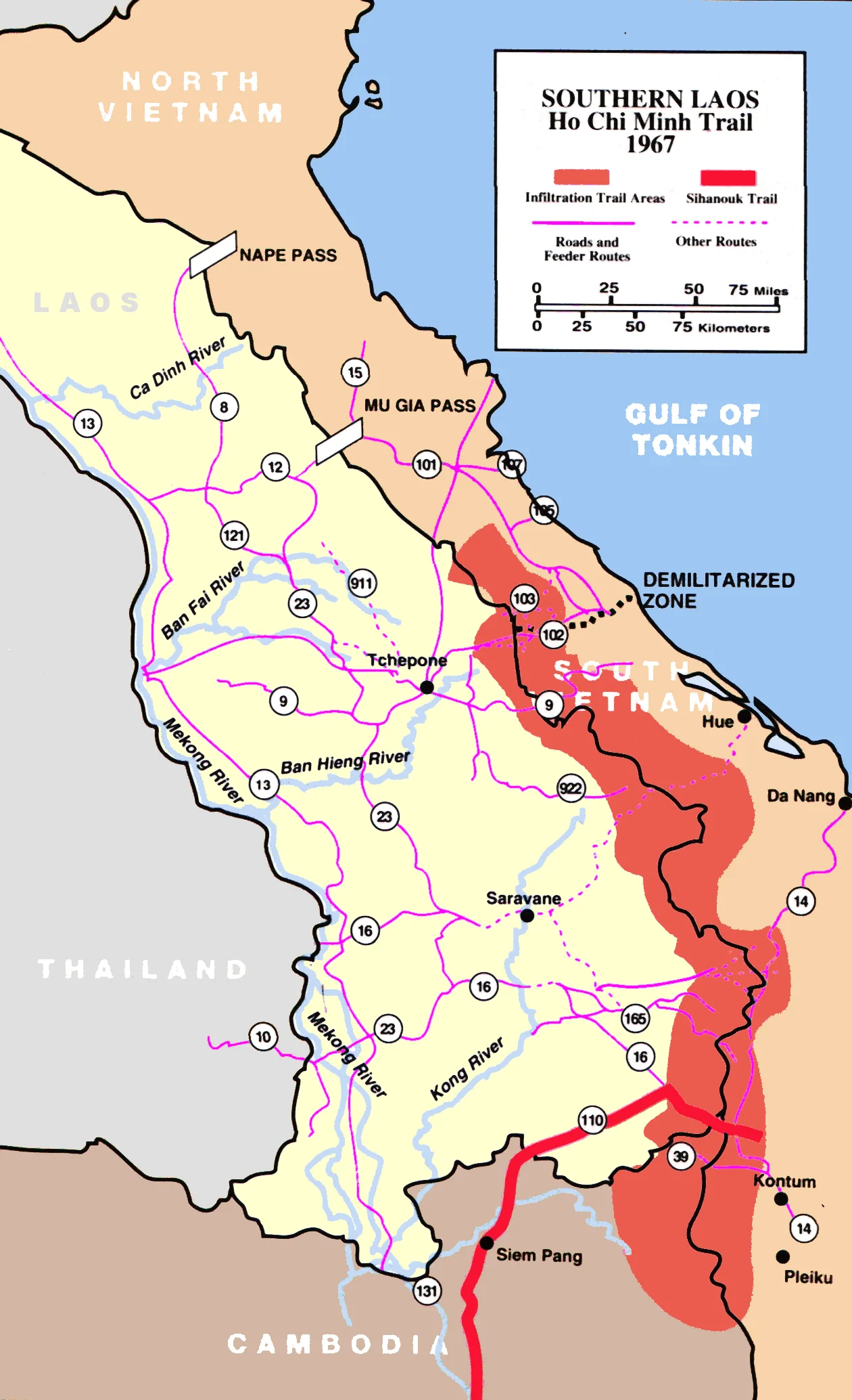

Ho Chi Minh Trail
The bridges were built underwater. Not low bridges, not camouflaged bridges — decks laid deliberately a few inches below the surface of the stream, so that a truck crossing appeared, from twenty thousand feet, to be driving on the river itself, and an empty crossing appeared to be nothing at all. By 1973 a driver could take a truck the entire length of the Trường Sơn supply route without ever leaving the tree canopy, except to ford a stream or roll across one of those submerged decks. That single detail explains more about the Ho Chi Minh Trail than any statistic: this was a road system designed, first and above everything, not to be seen.
Group 559
It began small. On 19 May 1959, North Vietnam formed a transport unit under the Rear Services General Directorate — a single battalion of 440 men, Battalion 301, known as Group 559 — to move people and supplies south. The Vietnamese called the route Đường Trường Sơn, the Trường Sơn Strategic Supply Route, after the Annamite mountains it followed; Americans named it for Hồ Chí Minh. By 1962 the group had grown to about 6,000 troops in two regiments, equipped with heavily laden bicycles and a handful of trucks. Within a year it stood at 24,000 troops and six motorised transport battalions. By late 1974 it numbered 100,495 people, and over the course of the war it moved more than a million tons of cargo. The capacity figures tell the same story from the other end: 20 to 30 tonnes a day in 1964, when American intelligence estimated that 12,000 North Vietnamese soldiers had walked south along it. The real figure that year was closer to 9,000.
Everything the Canopy Would Hide
What the maps called a trail was an 18-foot dirt roadway in places, gravelled and corduroyed with logs where the ground turned to soup, and a braid of footpaths, bicycle tracks and truck parks everywhere else. Underneath the trees sat supply bunkers, barracks, storage dumps, command posts and hospitals, screened by camouflage that was repaired and improved continuously. Way stations called binh trạm ran the logistics section by section. By the end of 1967 — the year Senior Colonel Đồng Sỹ Nguyên took command — the network included 2,959 kilometres of road capable of carrying vehicles: 275 kilometres of main route, 576 kilometres of bypass, and 450 access roads and storage spurs. When rivers ran the right way, they were used as conveyor belts. Food, fuel and ammunition were sealed into half-filled steel drums, launched into the Kong and Bang Fai rivers, and caught downstream in nets and booms. By 1970 six fuel pipelines were in operation, one of them crossing into Laos at the Mụ Giạ Pass; some 5,000 kilometres of pipe were laid in all.
The War Against Trucks
The American answer was airpower, applied for nearly a decade. Operation Barrel Roll began the first systematic bombardment on 14 December 1964; the first B-52 strike in Laos followed on 10 December 1965. From 1968 the effort was coordinated by Operation Igloo White, run from Nakhon Phanom in Thailand, and it was genuinely futuristic: air-dropped acoustic and seismic sensors seeded along the roads, computers in Thailand collating the returns and predicting where a convoy would be and when, and an orbiting relay aircraft vectoring strike aircraft onto the prediction. In 1969 alone, 433,000 tonnes of ordnance fell on Laos. The road stayed open. North Vietnamese anti-aircraft artillery thickened to match — radar-directed 37 mm and 57 mm guns by 1968, 85 mm and 100 mm pieces the following year, more than 1,500 guns defending the corridor by the end of the Commando Hunt campaigns. Meanwhile the CIA counted the other side's tools: twenty bulldozers, eleven graders, three rock crushers and two steamrollers, keeping ahead of the craters.
What It Cost
Nothing about this was cheap in lives. When South Vietnamese forces drove into Laos to cut the corridor in 1971, Hanoi chose to stand and fight with 60,000 troops; 108 helicopters were shot down and 618 more damaged in the fighting. In the conventional offensive of 1972 the North lost roughly 100,000 men killed and wounded, and around 30,000 South Vietnamese soldiers died. Behind the combat figures sit the people who simply maintained the road — filling craters, dragging wrecked trucks off the verge, staffing the bunker hospitals hidden under the trees, year after year, with the bombing a constant of daily life rather than an event. Many of them are buried at the Trường Sơn Martyrs' Cemetery on Highway 15 near Bến Tất, northwest of Đông Hà, which holds more than ten thousand graves of soldiers killed along the trail and on the demilitarised zone. Saigon fell on 30 April 1975, and the argument about whether the trail could ever have been closed by air was over. Today a paved national road, the Hồ Chí Minh Highway, runs down much of the same country.
From the Air
The trail was a network rather than a point; this entry is anchored at approximately 18.69°N, 104.84°E in western Nghệ An, near the trail's northern end, where roads out of the Nghệ An and Hà Tĩnh lowlands climb into the Annamite Range and cross into Laos. Fly it as a corridor: 8,000–12,000 ft AGL along the Vietnam–Laos frontier southward toward Quảng Bình gives the best appreciation of how completely forest and karst swallow a road. Navigate on the Lam River and Highway 7 to the north, the sharp border ridge to the west, and the Mụ Giạ Pass gap further south. Nearest airports are Vinh (VVVH) to the east, Đồng Hới (VVDH) to the south-southeast, and Vientiane–Wattay (VLVT) across the range in Laos. Haze and low stratus dominate the wet season from May to October — conditions that made visual interdiction largely futile and still make ridge crossings unwise; November to April is clearer and cooler.
Nearby Stories
- Northern Vietnam Lowland Rain Forests 6.4 km away
- Diễn Châu 8.7 km away
- Kim Liên Museum 10 km away
- Ban Nahin 32 km away
- Hà Tĩnh province 48 km away
- Northern Annamites rain forests 51 km away
- Viengxay Caves 159 km away
- Tha Rae 164 km away